
PRICE GUIDE

VIRTUAL TOURS & DIGITAL TWINS
CONSTRUCTION / PROGRESS MONITORING
MAPPING, SURVEYING & DATA CAPTURE
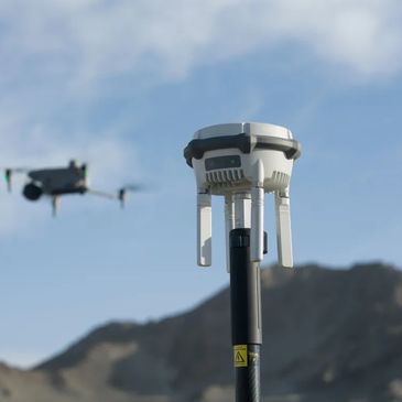
MAPPING, SURVEYING & DATA CAPTURE
CONSTRUCTION / PROGRESS MONITORING
MAPPING, SURVEYING & DATA CAPTURE
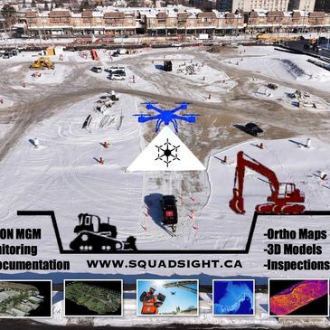
CONSTRUCTION / PROGRESS MONITORING
CONSTRUCTION / PROGRESS MONITORING
CONSTRUCTION / PROGRESS MONITORING

INSPECTION & ASSET ASSESSMENT
CONSTRUCTION / PROGRESS MONITORING
CONSTRUCTION / PROGRESS MONITORING
Virtual Tours & Digital Twins
Tier 1 - Virtual Tours
For property marketing and site overviews in the Greater Toronto Area, we provide exceptional drone services that include:
- Aerial drone capture
- 360° panoramic imagery
- Online interactive virtual tour (30-day access / extendable) - Web-hosted delivery through our RPAS Solutions.
Tier 2 - Digital twins
- For planning, stakeholder review, and visualization, our drone services in the Greater Toronto Area include a range of features designed to enhance your project management experience: - High-density image capture
- Interactive 3D site model
- Measurement & navigation tools
- Downloadable assets Our RPAS Solutions provide you with all the essential tools needed for effective project management.
Tier 3 - Enterprise Digital twins
For large developments and long-term asset use in the Greater Toronto Area, our drone services provide comprehensive RPAS Solutions that include:
- Large-area photogrammetry
- Higher-accuracy models
- Progress comparison capability
- Long-term hosting & update options.
Mapping, Surveying & Data Capture
Tier 1 - Mapping Essentials
For small sites and surface visualization in the Greater Toronto Area, we provide expert drone services. Our comprehensive package features:
- Orthomosaic map (≤10 acres)
- Basic 3D surface model
- Geo-referenced outputs, leveraging advanced RPAS solutions.
Tier 2 - Survey-Grade Mapping
For construction planning and quantity analysis in the Greater Toronto Area, our drone services offer exceptional RPAS solutions. This includes:
- Higher-accuracy mapping
- Volumetric measurements
- CAD/GIS-ready deliverables
- Technical summary report
Tier 3 - Engineering
For large sites or high-precision requirements in the Greater Toronto Area, we provide a range of comprehensive drone services that include:
- Ground control points (GCPs)
- Multi-flight missions
- Custom deliverables
- Engineering & workflow consultation with our expert RPAS Solutions.
Construction / Progress Monitoring
Single Basic Progress Capture
For milestones and documentation, our drone services in the Greater Toronto Area offer:
- Up to 25 high-resolution aerial photos
- 1 aerial video overview
- Consistent site viewpoints
- Up to 60 minutes on site
- Digital delivery
These RPAS solutions are designed to deliver comprehensive visual insights.
ONGOING MONITORING
Built for active construction sites requiring continuity, traceability, and risk reduction.
- Scheduled monthly flights (or bi-weekly by agreement)
- Repeatable flight paths & viewpoints
- Progressive visual record of construction
- Photo + video deliverables per flight
- Secure digital archive
- Priority scheduling
Use cases: GC reporting, owner oversight, lender visibility, and delay mitigation.
Engineering, Deliverable Add-on
Area, our drone services offer essential RPAS solutions that include:
- Engineering & workflow consultation with our expert RPAS Solutions.
- Scheduled flights across project phases
- Complete visual record of the build.
- Volumetric measurements
- Higher-accuracy mapping
- CAD/GIS-ready deliverables
- Ground control points (GCPs)
- Multi-flight missions
- Custom deliverables
Inspection & Asset Assessment
Tier 1 – Visual Inspection
For roofs, façades, and structures in the Greater Toronto Area, our drone services offer exceptional RPAS Solutions that capture detailed insights. Included are:
- Up to 25 high-resolution aerial photos
- Hard-to-access viewpoints
- Visual findings summary.
Tier 2 – Advanced Inspection
For deeper diagnostics and risk identification, our drone services in the Greater Toronto Area utilize advanced RPAS solutions. This includes:
- High-detail imagery
- Defect identification
- Inspection report
Tier 3 – Asset Inspection Programs
Our drone services in the Greater Toronto Area offer comprehensive solutions for portfolios and recurring inspections. This includes:
- Multi-site inspections
- Telecommunication infrastructure inspection
- Historical comparisons
- Maintenance planning support
- Annual or quarterly scheduling with our RPAS solutions.
All services are Transport Canada–compliant, insured, and delivered by licensed RPAS professionals. Pricing reflects industry-standard rates in Ontario. Final quotes depend on scope, site conditions, and deliverables. Contact us for a detailed proposal.
REQUEST A CUSTOM QUOTE AND WE’LL RECOMMEND THE BEST OPTion
All pricing is subject to the operational terms, conditions, and service requironments
All pricing is subject to the operational terms, conditions, and service requironments
All pricing is subject to the operational terms, conditions, and service requironments
All pricing is subject to the operational terms, conditions, and service requironments
All pricing is subject to the operational terms, conditions, and service requironments
All pricing is subject to the operational terms, conditions, and service requironments
This website uses cookies.
We use cookies to analyze website traffic and optimize your website experience. By accepting our use of cookies, your data will be aggregated with all other user data.